|

|
|
| Product Information: | ||
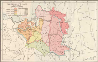
| Details: | 1772 - 1795 Partitions of Poland; by Herbert Adams Gibbons; 1 pp; Map; 10.5x14; published: 1915; Item # FS056 This is a full color reproduction of a map showing partitions of Poland during 1772 - 1795. . First Published inThe New Map of Europe (1911-1914). The Story of the Recent European Diplomatic Crisis & Wars of Europe’s Present Catastrophe.All of our maps come in a protective, archival safe sleeve. |
|